22 Oct UNMANNED AERIAL VEHICLES IN PRECISION AGRICULTURE
Bojana Ivošević
Research Assistant, Institute BioSense
As the world populations continues to grow we need innovative ways to feed more people sustainably. That means leveraging intelligence in the agriculture to make operations smarter and more efficient. At the centre of the smart agriculture expansion are agricultural robots, among which, unmanned aerial vehicles (UAVs) have gained much of the attention.
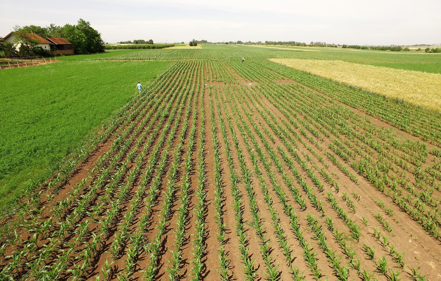
Offering a birds-eye-view, UAVs that carry sensors can spot and monitor potential anomalies on the field and reveal many issues such as soil variations, pest infestations and irrigation problems. On the other hand, in flying low and slow, UAVs proffer new opportunities for measurement of agricultural phenomena, delivering fine spatial resolution data at user‐controlled revisit periods. Get closer to the field and you might be able to see not just broad view, but each individual plant in it (Figure 1). Higher spatial resolution doesn’t just look better. Alhorithms can segment plant signals for more accurate and sensitive results, earlier detection of health issues and advanced data types. UAV data acquisition is generally managable and not as influenced by cloud cover. Ongoing miniaturization of measurement technologies, i.e. smaller payloads and developments in navigational capabilities will enable datasets that, until now, farmers have only dreamed of collecting.
Figure 1. Corn field captured with UAV Inspire 1
Crop monitoring is tricky, and any issues with the field can be easily hidden by its abundant foliage while uneven topography often includes areas of soil instability, making it difficult to diagnose and treat issues before they affect the plants. The canopy can also obscure differences in elevations and depressions of the field that can present difficulties in harvest and roading. The spectral response of the vegetation is unique, as it reflects plant’s health itself, and is highly dependent on solar radiation, soil properties and available nutrients.
Normalized Difference Vegetation Index (NDVI) so called ²index of greenness² is useful for determining the productivity of vegetation because chlorophyll absorbs light strongly in the red region of the spectrum while leaf cell structure reflects strongly in the NIR region and the rate of photosynthesis is positively correlated with the amount of photosynthetically active radiation absorbed by the plant. By examination of the NDVI and other similar indices farmers are able to identify variability within crops and make adjustments to applications rates of crop additives such as fertilizer and pesticides by employing variable rates of application. However, it is always advised to combine NDVI along with other parameters to get better results.
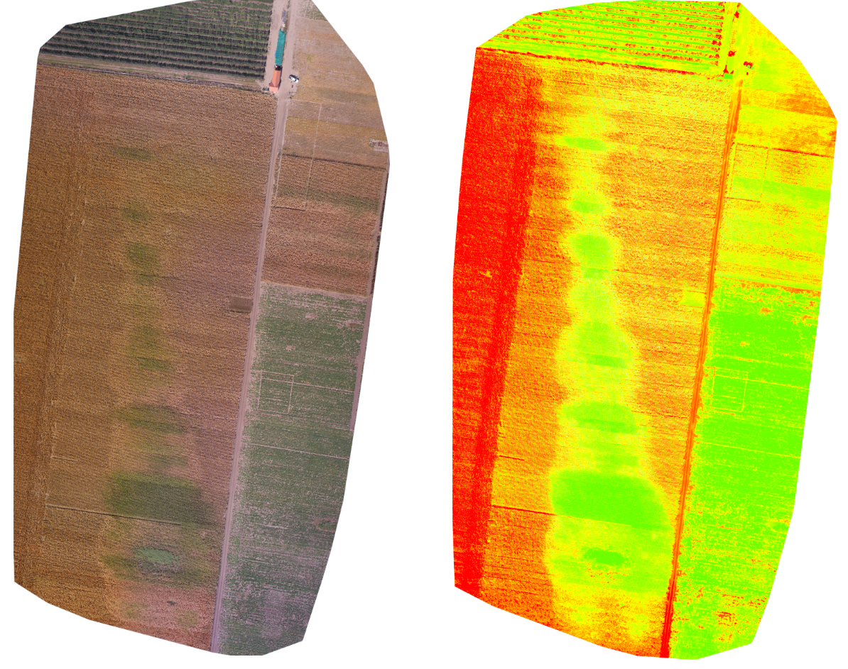
Figure 2. Generated orthomosaic with images acquired with RGB camera (left) and NDVI index map obtained from NDVI modified camera (right)/p>
We flew aerial survey grids over maize crop with a DJI drone Inspire 1 carrying the RGB and modified NDVI camera alternately. The aerial images were processed in Pix4Dmapper photogrammetry software to generate orthomosaic and NDVI index map (Figure 2). Throughout all growing seasons, NDVI can be helpful to ag professionals by providing information about plant health status in early stages invisible to the human eye across the electromagnetic spectrum.
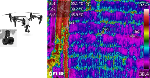
Figure 3. DJI Inspire 1 equipped with Zenmuse XT Thermal camera (left); thermogram showing different temperatures in the corn field (right)
Thermal sensors are widely used for estimating water stress application within agriculture. The explanation behind is that water stress induces a decrease in stomatal conductance, causing a detectable increase in canopy temperature. As a result we only see images of the radiation called thermograms (Figure 3) presented in a form of colours of the rainbow (red to violet) within the visible light spectrum.
In conclusion, each type of stress has specific aspects and factors that need to be considered when monitored by UAVs. UAVs will never entirely replace the human on the field but are undoubtedly revolutionizing global agriculture by offering advantages over other methods because they can provide information on the temporal and spatial heterogeneities of the boundary layer, in both horizontal and vertical domains.